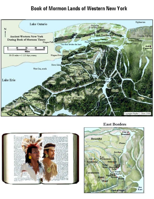
CHOICE ABOVE ALL OTHER LANDS
Book of Mormon Covenant Lands
According to the Best Sources
Olive's
Near Cumorah Setting
By Deduction and Best Fit
W.
"And it came to pass that when he had poured out his soul to God, he named all the land which was south of the land Desolation, yea, and in fine, all the land, both on the north and on the south - A chosen land, and the land of liberty." (Alma 46:17)
What can we conclude from LDS scripture and statements made by Joseph Smith about the location of the ancient covenant "land of liberty" described in the Book of Mormon?
Certainly there are keys in scripture identifying covenant lands. The "new covenant, even the Book of Mormon" with its painstakingly engraved geographic details, was written with the house of Israel in mind. The placing of keys in scripture that logically outline covenant lands, is a service that the LORD provides for his people Israel. This does not mean that scripture pinpoints the exact location of the city Zarahemla. But the general whereabouts of the principal lands of the Book of Mormon can be deduced from scripture in three steps!
Introduction - Promised Lands by
Establishing the Book of Mormon's setting by devotion to scripture should precede archaeological investigation of its sacred history.
Compared to
rivers in his own country, Namaan
the Syrian was not impressed with "the waters of
Though experts disagree on the extent to which the Bible should be regarded as history, religious and secular scholars of the Bible at least agree on the Bible's general setting. Mainstream American History and Literature specialists place the literary setting for the Book of Mormon among the mysterious "Mound-builders" of Joseph Smith's own country. Enough written interest exists from the 19th century on the topic of the "Mound-builders", to constitute a unique American genre. (Robert Silverberg, "...and the mound-builders vanished from the earth", American Heritage Magazine, June 1969, Volume 20, Issue 4; See also Roger G. Kennedy, HIDDEN CITIES " THE DISCOVERY AND LOSS OF ANCIENT NORTH AMERICAN CIVILIZATION, 1994, pp. 228-231)
Salvatore M. Trento, author of several books on North American relics, regards the Book of Mormon as "an astonishing tale that fits very well with the general outlook in the early 1800s on the American wilderness." Trento notes that, "As American Settlers pushed west into New York State and into the Ohio River Valley, they actually did see evidence of an ancient civilization..." Though discounting visions and angels, Trento nevertheless concludes that young Joseph Smith probably did find buried metal "tablets engraved with weird markings". "Joseph Smith probably uncovered something from another time, another culture," writes Trento, "and it changed him." Trento does not attribute Joseph's find to some singular ancient individual traveling thousands of miles from Central or South America. Trento notes that in the Northeast "There are dozens of reports over the past two hundred years of farmers finding buried stones with inscriptions...intriguingly, in other parts of eastern American, some unknown group of people left slabs of stone etched with a script used in ancient Mediterranean countries." (Salvatore M. Trento, FIELD GUIDE TO MYSTERIOUS PLACES OF EASTERN NORTH AMERICA, pp. 240-244)
Establishing the Book of Mormon's setting by meticulous attention to the text should precede archaeological investigation of its sacred history. Archaeology and the search for scriptural sounding names, is not the best way to go about finding a Promised Land. More than a few ancient peoples inscribed on metal and stone and worked in earth, timber and plaster-like cement (burnt limestone). (Leviticus 14:42, Isaiah 33:12) Mound Builders of North America made wattle and daub houses of "cement" and were accomplished artisans in wood, metal and stone.
Scriptural
sounding names turn up
in diverse places. There are numerous place names in western New York
and the Great Lakes area in general, that sound strikingly like Book of
Mormon names. "Oneida" for instance.
(Alma 47:5)
But care must be taken with scriptural sounding place names.
The Bible makes demographic claims that are not easily proven archaeologically. (2 Samuel 24:9, 1 Chronicles 21:5) According to the Bible, more than a million people were led out of Egypt - bound for a relatively small Promised Land. (Numbers 1:45-47) Yet, population controversies do not keep biblical scholars from agreeing on the location of Canaan. Likewise, the Book of Mormon's literary setting, does not require archaeological proof of its demographics. In other words, archaeological proof of larger Israelite populations is not required to establish the legitimate covenant land literary setting of either the Bible or the Book of Mormon.
Yes, there were a lot of people anciently in Central and South America, but there is no strong evidence that a large population matching the description of Nephite civilization, ever existed there. The general setting described in scripture should be established as much as possible by scripture. Central and South American settings are not better fits demographically than Joseph Smith's American Israelite setting among the Mound Builders. To try and locate the geography of the Book of Mormon by archaeology, including demographics and the occasional discovery of a scriptural sounding name, is to place the proverbial cart before the horse. In short, we should carefully attend to the text before we take up the pick and shovel. We should let the text tell us where to dig. After all, if we find evidence of synagogues, Hebrew writing, prayer shawls and copious Old Testament names in Poland, it doesn't prove that the site of ancient Hebron is nearby.
The Bible tells us that Solomon's temple stood on
The fact is, the location of the Book of Mormon land
Cumorah
is as established in LDS scripture as
The Book of Mormon is equated with the fullness of "the Gospel" and "the new covenant". (1 Nephi 10:13-14, D&C 20:8-9; 84:57)
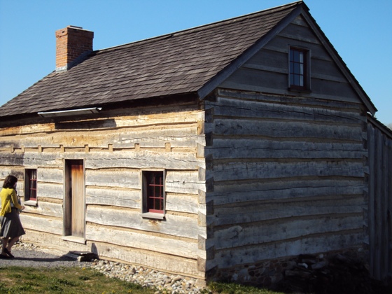
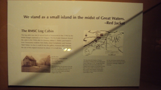
A
reconstruction of the Smith family home in the
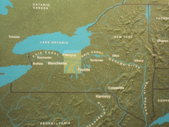
"... in a land of many waters ..."
Map displayed at the
LDS scripture contains in written form "the new covenant". (D&C 84:57) "All covenants between God and man are part of the new and everlasting covenant. (D&C 22; 132:6-7)" (Bruce R. McConkie, Mormon Doctrine, New and Everlasting Covenant, pg. 530) It stands to reason that scripture and verifiable statements by the Prophet Joseph Smith would suffice to identify the general whereabouts of covenant lands. Covenant lands are part of "the new covenant" and the fullness of the Gospel contained in LDS scripture. The subject is not just about geography. A covenant is an agreement between two or more parties. Scripture contains keys enabling heirs to identify the covenant lands of their fathers. This is a service provided by the God of Israel to his people.
Not long after the Messiah personally ministered to the Nephite people, the good people of the church were found disputing with one another over a particular matter. The church leaders presumed that the answer was not revealed in scripture, and were "united in mighty prayer and fasting", seeking revelation from God. "Jesus stood in the midst of them" and asked what it was they desired. The Savior was told concerning the public controversy, to which he responded "why is it that the people should murmur and dispute because of this thing? Have they not read the scriptures ... ?" (3 Nephi 27:1-5) This account can help us realize that there is a difference between admitting that we do not know or understanding something, and claiming that God has not revealed it. The Apostle Paul taught that "we know in part, and we prophesy in part." (1 Corinthians 13:9) The Lord's meek servants will be the first to admit that they do not understand all that God has revealed in scripture. As important as it is to encourage unity and avoid embarrassment, it is also important not to offend the God of Israel by claiming he has not revealed a matter in scripture, when he has.
According to scripture, the principal lands of the
Book of Mormon cannot be thousands of miles distant from
Cumorah. In seeking the Promised Land of the Book of Mormon there
is no need to rely on extraneous works like John Lloyd Stephens' Incidents of Travel in
Central America. Early Latter-day Saints placed undue weight on
Stephens' 1841 bestseller, promoting it as an essential guide to Book of
Mormon cities, despite the fact that Stephens himself was of the
opinion that the Central American stone ruins which he and Frederick Catherwood documented were comparatively
modern. (Incident of Travel in
Central America, Vol. II, Chapter XXVI, "COMPARATIVE MODERN DATE OF
RUINS", pp. 442-443) This infatuation
with stone ruins in Mesoamerican jungles has led to confusion and
disappointment among the faithful.
The Book of Mormon was
published more than a decade prior to Stephens' bestseller. In
1832, the Lord in a revelation to Joseph Smith, warned the Saints not to
persist in treating the Book of Mormon lightly.
(D&C 84:54-57)
"Cumorah"
is mentioned in the Prophet's September 6th, 1842 epistle to
the church. This epistle deals mainly with the topic of baptism for the dead. Joseph
previously announced this epistle as "the word of the Lord".
(D&C 127:10) The Prophet's epistle has been canonized by the
But the practice of baptism for the dead is not recognized by the "Community of Christ" (formerly Reorganized LDS church) as doctrinally binding upon its members. (RLDS D&C 110; see also RLDS D&C 107) More than one 20th century RLDS writer came to dismiss the location of Cumorah given in Joseph Smith's September 6th, 1842 epistle on baptism for the dead. (LDS D&C 128) The original Cumorah was sacrificed to accommodate a Mesoamerican geography. RLDS writers L.E. Hills and J.F. Gunsolley are the earliest known proponents of Central American Cumorah theory. Thus, the "limited" Mesoamerican setting follows a later tradition that departs from the "Mound-builder" literary setting recognized by mainstream scholars.
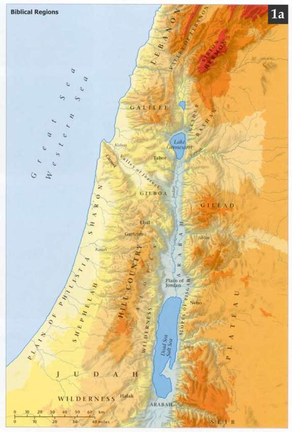
Israelite coordinates:
The little
Though there is little archaeological evidence supporting the Bible's demographic claims, the population densities in the land, according to scripture, were astonishing! (2 Samuel 24:9, 1 Chronicles 21:5, 1 Nephi 21:18-19) Much Biblical history concentrates in this small land. The setting for the Book of Mormon is comparable in size and demographics. The ultimate inheritance of Lehi's posterity, however, may not have been limited to the principal lands near the coast of the "west sea". Book of Mormon "south countries" may have extended southward through open country; limited only by the seasonal requirements of the Law of Moses. (Mormon 6:15, D&C 75:8)
To begin, the lands of the Book of Mormon are oriented according to Israelite directions. These are the same directions represented in the Bible. The Semitic coordinate system is based on the perceived movements of the heavenly quarters. The lights in the firmament were not only seen as good for marking the passage of time; they also provided convenient signs for discerning direction. (Genesis 1:14) The notion that Book of Mormon peoples, who kept all of the commandments and ordinances of the Mosaic Law, would have used a different system for coordinating directions, is an embarrassingly gentile argument. Israelite East is in the general direction of sunrise. (Numbers 2:3) West is in the direction of sunset. (Joshua 1:4) If there is a sea in the direction of sunset, then it is acceptable to speak of west as seaward. If there is a desert to the south, then it is acceptable to speak of south as desert-ward. But it is sunrise that sets the compass in the Promised Land, and not one's back to an arbitrary seacoast or a desert arbitrarily on the right-hand. To teach otherwise is to misrepresent how Israelite directions work.
The fact that proper Hebrew
(biblical) directions are correctly translated in
1 Nephi 16:13;
17:1
and in the Book of Mormon's Isaiah portions, is strong evidence that the
coordinate system used throughout the English Book of Mormon is the
biblical coordinate system. ("Israelite Compass")
As in the Bible, "up" and "down" in the Book of Mormon indicate changes in elevation. (Zechariah 14:17, 1 Nephi 4:1)
There are notable similarities between The Book of
Mormon setting in western
Both settings locate in the temperate Northern
Hemisphere, subject to seasons that are essentially in phase with each
other. We may deduce this from the fact that it was the "first month" of the
Israelite year in both the American
Promised Land and in the
Both the principal Book of Mormon setting and the
Both covenant lands feature east and west inland
seas. In both lands, the eastward seas are smaller than the west sea.
One of the eastward seas is actually named "the east sea". (E.g.
the
In
"... the Lord has made the sea our path, and we are upon
an isle of the sea. But great are the promises of the Lord unto them who
are upon the isles of the sea; wherefore as it says isles, there must
needs be more than this, and they are inhabited also by our brethren."
(2 Nephi 10:20-21)
Jacob here refers to "the isles of the sea" mentioned in Hebrew prophecy (e.g. Isaiah 11:11; 24:15; 42:10). The Hebrew word "iy" (אִי), translated "isle", does not necessarily mean an island in the sense of a small landmass entirely surrounded by water. The Hebrew word means a coast or a habitable spot. (Brown-Driver-Briggs-Gesenius Hebrew-Aramaic Lexicon, אִי ,339, pg. 15)
Searching
the words of Isaiah, we find that the prophet regards coastal countries
as "isles".
(Isaiah 23:2,
6) The coast of
Commenting on the meaning of the word "isle" found in Jeremiah 31:10, Ethan Smith, a contemporary of Joseph Smith, remarked:
"He that scattered Israel will gather him, and keep him as the shepherd doth his flock." "Isles afar off!" "Isles in the Hebrew language, signify any lands ever so extensive, away over great waters. Where can these "isles afar off," (these "coasts of the earth," here addressed by God in relation to the restoration of his outcast yet beloved Ephraim,) where can they be so naturally found as in America?" (A View of the Hebrews or The Tribes of Israel in America, 1825 edition, pg. 231)
The expression, "... the Lord has made the sea our path ..." is rich in meaning. These words recall a verse from Hebrew scripture: "Thy way is in the sea, and thy path in the great waters ..." (Psalm 77:19, KJV) The Hebrew word translated "path" is "sh'vil" (שְׁבִיל). This word literally means a track or passage-way (as if flowing along). A related word, pronounced "sh'bolet" can mean flowing stream. (Brown-Driver-Briggs-Gesenius Hebrew-Aramaic Lexicon, שְׁבִיל ,7640, pg. 987)
The Hebrew
expression, "mayim rabim" (מַיִם
רַבִּיִם), translated
"great waters" or "many waters" doesn"t exclusively mean the Ocean.
The expression also applies to inland waters including large rivers.
(Jeremiah 41:12,
51:13,
36,
Ezekiel 17:5,
8;
19:10)
Nephi recounts in his introductory summary to the First Book of Nephi, that his family
not only crossed "the large waters" to the American Promised Land; they
crossed "large waters into the promised land".
(1 Nephi 1)
Jacob"s comment about the Lord making "the sea our path" could apply to Ocean currents, but it could also describe the experience of being divinely guided across a gulf or bay and up the flowing channel of a river. Lehi"s company could have perceived their voyage along an American water-way or passage as a continuation of their sea crossing. (Mosiah 10:13) They may have viewed the mouth of a major river as the Lord literally making the sea into a flowing "path".
Mighty rivers can be called "seas" in Hebrew scripture. (Isaiah 19:5; 21:1, 27:1, Jeremiah 51:36, Nahum 3:8, Ezekiel 32:2; the scriptural references to "dragon" and "whale" may actually intend a crocodile) The experience of being guided by "Liahona" in a deliberate course across a gulf and up the strait and narrow waterways to their inheritance, may have so impressed the company of Lehi, that it reinforced a Nephite allegory: The Lord leading "the man of Christ in a strait and narrow course across that everlasting gulf" to "land their souls..." (Helaman 3:29-30) Church history gives an example of a similar voyage against the current "into the promised land": Wednesday, July 6, 1842 tells of an expedition of fifty brethren in sloop-rigged keel boats, headed a considerable distance up the Mississippi to procure timber for the Temple and Nauvoo House. (History of the Church, Volume 5, pg. 57)
Like the "isle" of
An exhibit on display at the Rochester Museum of Science, featuring a map of the locations of Seneca reservations in western New York following the treaty of Big Tree in 1797. The native peoples of these reservations are identified in LDS scripture as "the Lamanites". (D&C 32:1-2)
Names of waters and lands, and their relative directions -
an important distinction:As with the biblical "east sea" and "west sea" (translated, "utmost sea" in Joel 2:20, KJV), the proper nouns "east sea" and "west sea" in the Book of Mormon, actually name bodies of water. These Book of Mormon seas border limited territories and are not mentioned north of specific locations. (Alma 22:32; 50:13; 52:12) Because "west sea" is a name, the sea is called by its name even when the sea is approached from different directions; thus the expression "west sea, south". Here, the name of the sea is followed by the adverb "south" directing towards a shore of the "west sea" from a northern location. (Alma 53:8, 22)
The expressions "sea, on the east", "sea east", "sea west", "sea north", "sea south" all require a frame of reference in order to identify the body of water. These relative expressions do not name the seas. The expressions indicate the direction to the body of water relative to a position. (Alma 22:27, Helaman 3:8) In each case, the scriptural reference frame needs to be determined in order to identify the body of water. Similar expressions are found in the Bible. (Joshua 18:14)
Just as the expression "sea east" does not
name a body of water, the relative expressions "land northward"
and "land southward" do not name Book of Mormon lands. The
expression "land southward" for instance, is used to refer to
lands south of the "small neck of land". (
The Promised Land of the Jaredites is the Promised Land of the
Nephites. Both Book of Mormon peoples inherited lands in the prophetic
"land of liberty", blessed to become the
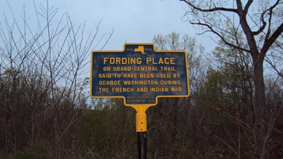
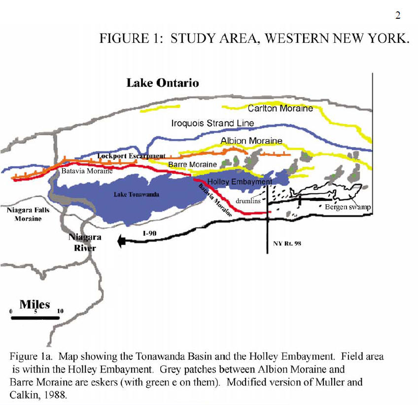
A marker posted in
western NY, just north of Indian Falls and the Onondaga Escarpment, not
far from the narrow Batavia Moraine that passed through ancient Lake
Tonawanda.
1. Joseph Smith published an editorial indicating
that the Jaredites arrived in "the lake
Unsigned newspaper articles, speculating on the
placement of Book of Mormon sites, are not reliable as sources for
establishing the authentic setting for the Book of Mormon.
2. We conclude from scripture that the Jaredites
inherited a coast of Lake Iroquois (ancient
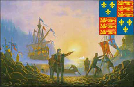
John Cabot (Giovanni Caboto) is officially credited with the discovery of the North American continent.
The LDS Church edition of the Standard Works, is careful not to specifically reference Christopher Columbus as the "man among the Gentiles" in Nephi's vision. (1 Nephi 13:12-20) John Cabot fits well the context of Nephi's vision. Nephi saw the future land of his father's "inheritance" - a land in the temperate Northern Hemisphere, accommodating all seasonal requirements of the law of Moses. (2 Nephi 5:10) Nephi's vision goes on to describe pilgrims seeking freedom, the American War of Independence from Great Britain, and the rise of the United States of America, "lifted up by the power of God above all other nations". (1 Nephi 13:30) Christopher Columbus discovered certain islands of the Bahamas and the Caribbean. Columbus eventually sailed along the coast of Central America. The notion that Columbus was the first European to discover the American continent is a myth. John Cabot's discovery alone was sufficient to initiate European migration to North America.
LDS scripture does not indicate that the Book of
Mormon "land of promise" occupies the entire land mass of the
3. The Mulekite landing and Jaredite settlements were
in a "land northward" from the land
As the Nephite nation retreated "towards the north
countries" before their enemies, the Nephite "lands of
inheritance" were divided. The Nephites were given "all of the land
northward". (Mormon 2:28-29). A distant land northward features
"large bodied of water and many
rivers". Seas are mentioned (not by name) in each of the cardinal
directions bordering this land northward.
(Helaman 3:8) The "land
northward" or "north countries" comprise more than one
country. Scripture does not indicate that all the "land northward"
resides within the borders of the
4. The Jaredite ruler Coriantumr progressed "eastward" from Moron to the hill Ramah in the land Cumorah, indicating that Cumorah (in a land of many waters), is eastward from the Jaredite seat of power at Moron, that is, eastward from the "small neck of land" in the land of Desolation (near Moron). (Ether 14:6-7, 26; 15:8-11; Alma 22:32; Olive interprets that "the narrow neck of land" and "small neck of land" refer to the same geographical feature) Moreover, the overthrown Jaredite king Omer departed the land of Moron near Desolation (north of Zarahemla and Bountiful, Ether 7:5-6; 9:3) and "came over" (eastward on the plains, Ether 13:28-29; 14:15) near Cumorah, south of the great waters of Ripliancum, (Ether 15:8, 10-11, Mormon 6:5-6) and from there continued "eastward" to a "seashore" (the northern end of Cayuga Lake qualifies).
Scripture
indicates that the American territory of the Jaredites (near
5.
Cumorah resides in "a land of many waters, rivers and fountains".
(Mormon 6:4) The general location of the land Cumorah is near the
Finger Lakes of western NY - east of
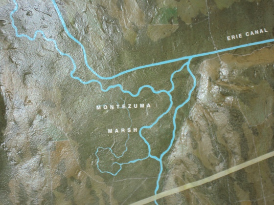
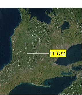
Map depicting the Montezuma Marsh -
6. The Jaredite land "among many waters"
in the general region of Cumorah, was so near to the land of Zarahemla,
that travelers from the land of Nephi (south of Zarahemla)
mistook the land of the Jaredites destruction for Zarahemla.
(Mosiah 8:7-8;
21:25-26,
Alma 22:27) Therefore the
LDS scripture does not say that the Book of Mormon
land and city of
7. Lehi"s company was directed so far northward in their American inheritance, that they encountered "driven snow". Hence the non-biblical expression translated "whiteness of the driven snow", which Nephi used to describe the Tree of Life to generations of his own people in the Promised Land. (1 Nephi 11:8; 19:1-3, 2 Nephi 5:28-32) This land of inheritance extends to and includes a place by the west sea. (Alma 22:28)
Considering the aged condition of Lehi and Sariah it stands to
reason that the shore of the west sea was not a great distance
from where Lehi"s company finally disembarked. They thus arrived by boat at a location,
near the west sea. Smaller craft likely served
them as the need for going ashore for freshwater and other supplies
presented itself. These many necessary excursions, of course, would not
come to occupy the available Nephite record. Lehi's company could have
sailed and or rowed up
the interconnected
If Wilford Woodruff, in a skiff, could row against the current of the Mighty Mississippi to Nauvoo, while afflicted with a "Billious fever", Lehi's party, divinely guided, could certainly have sailed and or rowed their way up the American Nile and Ohio River; despite whatever cataracts may or may not have posed a hindrance. (Wilford Woodruff's Journal, August 2, 1842, 2:185) From the Ohio, they could have found their way up the Allegheny and French Creek to within walking distance of the freshwater west sea - Lake Erie.
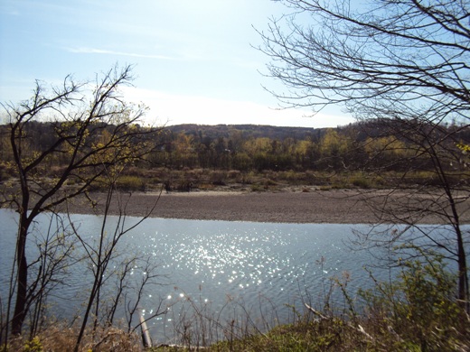
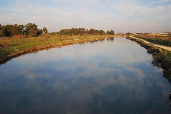
Alternately they could have sailed from the south along the Eastern Seaboard to Chesapeake Bay, and then to the mouth of the Susquehanna River. The western branch of the Susquehanna leads to lands and other water-ways near Lake Erie.
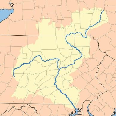
The Susquehanna River - an alternate way leading to lands near Lake Erie
It is
evident from scripture that "sea" and
"sea shore" can refer to a freshwater lake and lakeshore. (Matthew
13:1-2; see Hebrew Matthew (B'sorot Matti) 13:1-2 and
Numbers 34:11,
Deuteronomy 3:17,
Joshua 12:3,
13;27) There is nothing in the Book of Mormon indicating that
the
west sea is open ocean, and not an
inland sea like the western sea of the Bible.
The "place of their fathers" first inheritance"
(Lamanite and Nephite) is "on the west in the
The shore of the Book of Mormon west sea (west
of both the lands of Zarahemla and Nephi) at least extends
from the
The land of Helam is probably not northward, or in the direction of Zarahemla from Lehi-Nephi. Why? The Lamanite army who stumbled upon the land of Helam while trying to find the not too distant land of Nephi, had been in pursuit of the people of Limhi for only 2 days before "they could no longer follow their tracks; therefore they were lost in the wilderness." (Mosiah 22:16; 23:30-35) The people of Limhi did not start out in the direction of Zarahemla but "bent their course towards the land of Zarahemla" after traveling "round about the land of Shilom", in other words, they diverted the pursuing Lamanites, quite possibly by starting out in the opposite direction of their destination. (Mosiah 22:8-13) It is unlikely that the pursuing Lamanites marched due east or due west, otherwise they would have come to either the sea on the east or the west of the land of Nephi. (Alma 22:27-28) It is therefore most likely that Helam, a pleasant land of "pure water", is southward from the land of Lehi-Nephi, and that the actually distance between the lands of Lehi-Nephi and Zarahemla, is closer to the estimated 4 days on foot.
One doesn't have to travel far in woodlands to get lost and remain lost "many days". Incidents of wandering "many days in the wilderness" do not give reliable metrics for determining the relative distances between Book of Mormon lands. (Mosiah 7:4-5) The children of Israel wandered many years in the wilderness before entering their relatively small Promised Land. This does not mean they wandered from Africa to China.
According to scripture, how far northward do the lands of Zarahemla
and Bountiful extend? Consider Helaman's 2 day march northward.
He and his stripling
warriors starting their march just north of the
Th
Lake Iroquois/Ontario, with its watery fenlands to the north of
Cumorah, must be the Book of Mormon waters of Ripliancum.
Conclusion 1, Waters of Ripliancum:
By interpretation, Ripliancum is "large, or to exceed all".
(Ether 15:8) Lake Iroquois/Ontario, with its
watery fenlands
and channels constitutes the
Book of Mormon waters of Ripliancum. It is the largest of inland
bodies of water in the The
The Book of Mormon west sea must be
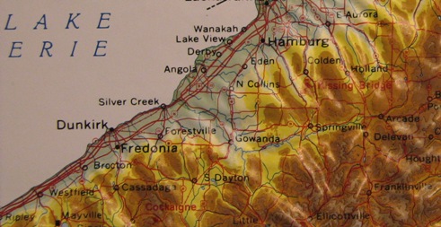
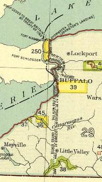
Conclusion 2, the The Early Mormon missionaries were sent by revelation to
"remnants of the house of Joseph, the Lamanites residing in the
west". They visited "Indian
encampments near the city of Buffalo", western New York - near
Lake Erie. (History of the Church, Volume
1, pp. 118-120) Source Articles: 8. It was only the distance of a day and a half's
journey for a Nephite on the line There is no firsthand statement by the Prophet Joseph
Smith placing the Book of Mormon Though the Levi Hancock journal remark about "the
land of desolation" carries little weight, because it is not a firsthand
statement by Joseph Smith, the statement should nevertheless be viewed
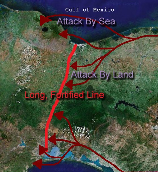
as more substantive than the Missouri "Manti" and 9. A fortified line near the southern borders of
the There was a sea on the east of the 10. The land and city of Manti may not have been more than a
day's march from Helaman"s position at Cumeni, one of the
fortified cities stationed between Manti and west sea.
Previous to this, Helaman was stationed a night's march westward near
the west sea. (Alma 53:8,
22;
56:1,
9,
13-14,
31;
57:7-8;
58:13-14) Cumeni was so
near to Manti and other "retreats" and "strongholds"
that Lamanite sorties could sally forth, attempting to lure Helaman
out of the city of There is no verifiable statement by Joseph Smith
placing the Book of Mormon Manti near
"A mile and a half west of Huntsville we
crossed the east branch of Chariton, and one and a half miles west of
the river we found Ira Ames and some other brethren near the place
where the city of The Prophet Joseph Smith did not ride out to meet the
Kirtland camp until October 3, 1838. He and other brethren escorted the
camp to Seas bordered the lands of Nephi and
Zarahemla on the east and on the west. A "narrow
strip of wilderness" ran between the lands of Nephi and
Zarahemla from the east sea to the west sea.
(Alma 22:27;
27:14)
Moroni fortified the wilderness "line"
between the land of
Zarahemla
on the north, and the
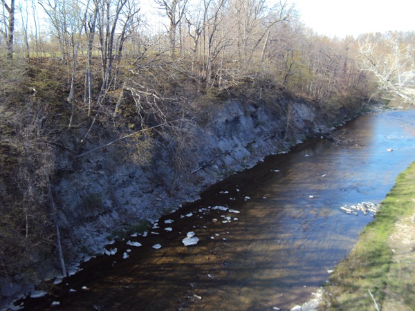
Looking southward, the elevated land of
Nephi is seen in the distance, viewed from the "narrow strip of wilderness" - the east
to west running
Cattaraugus River Corridor.
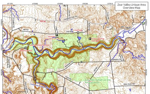
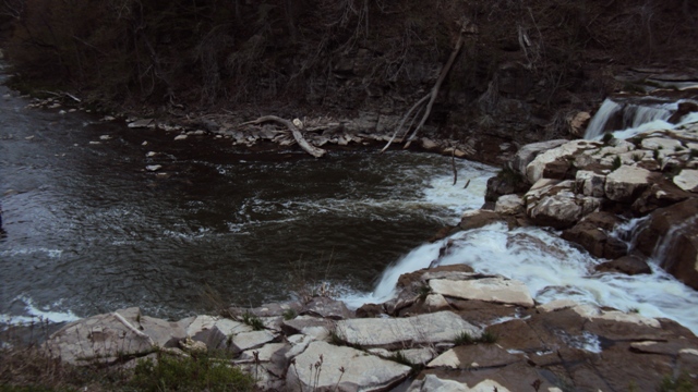
Zoar Valley
Canyon in the Cattaraugus River Corridor -
the "narrow
strip of wilderness". The east to west flowing Cattaraugus Creek is
somewhat analogues to "nahal
Qanah", the creek,
or wadi that divides a land of Manasseh (north), from the land of
Ephraim (south) in the
biblical Land of Israel. Many tribes mentioned in the Book of Mormon
(1 Nephi 7:2,
Alma 3:7),
who inhabited lands south of Cattaraugus river, were likely related more to Ephraim than to Manasseh (Alma 10:3).
Cattaraugus Creek flows to the
"west
sea" along a wilderness corridor.
The eastern end of the corridor is by the head of the northward flowing
Buffalo Creek/River, north of present day Arcade.
(Alma 22:27;
50:11)
Cattaraugus River
Corridor, recognized by secular authorities as the dividing line
between two distinct ancient American cultures. (Olive, Phyllis, We
are Israel; DVD)
According to scripture, the lands of Conclusion 3, the
Three Lines defining the breadths of the Lands (1) The "line which was between the land (2) The southern fortified line of (3) Even farther south, the fortified "line
between the Nephites and the Lamanites, between the land of Zarahemla
and the land of
Nephi, from the west sea running by the head of the
river Sidon ...", in other words, following the
course of the narrow strip of wilderness "from the east sea to
the west". Scripture indicates this line may have taken about a 2
day journey. It is evident that the principal lands of the Book of
Mormon from the narrow strip of wilderness in the south, to the
line Based
solely on LDS scripture, we see that the Book of Mormon's setting can be
deduced - its sacred geography located and outlined! Early Saints got
into trouble by searching first, over the vast Western Hemisphere, for a conspicuous "small neck of
land", or by trying to match Book of Mormon cities with
ruins described in Stephens' bestseller.
It is more important to make certain that the general location and relative distances match
scripture, and that the elevation of the land increases from north to
south as described. With the
waters of Ripliancum and the west sea deduced (given the
location of Cumorah), and with the inland breadths of the lands A
similar relationship exists between the Old World covenant land of Israel and the Bible. The Bible
contains written covenants between GOD and
Other Covenant Land
features by Best Fit Conclusion 4,
natural linear features and the southward rise in elevation:
The Onondaga Escarpment is a long running vertical relief, capped by
"Onondaga Limestone". The escarpment runs roughly east - west, and
situates to the north of Further south, and at even greater elevation, is a
second wilderness "line" - the Cattaraugus Narrow. This narrow
wilderness feature runs from the east to the west sea (Lake Erie)
a distance consistent with the estimated distance of the "straight
course" between the
Indian
Falls, Tonawanda Creek spilling over a small portion of the Onondaga
Escarpment
Source
Article: 11. Connecting the land northward (including Jaredite
land on U.S. soil) with a land southward, the "small neck of land", "pass" or "passage", passed
through a "sea" (singular) such that the waters of the sea were
seen nearby "on the west and on the east" of the "narrow pass".
Addressing the relative size of the "narrow pass", the
Desolation /
The small neck "by" the Desolation / "And they came from there up into the south
wilderness. Thus the
land on the
northward was called Desolation, and the land on the southward was
called Bountiful, it being the wilderness which is filled with
all manner of wild animals of every kind, a part of which had come from
the land northward for food. And now, it was only the distance of a day and a
half's journey for a Nephite, on
the line
Bountiful and the land Desolation, from the east to the west sea;
and thus the land of Nephi and the land of Zarahemla were nearly
surrounded by water, there being
a small neck of
land between the land northward and the land southward." ( "And it came to pass that Hagoth, he being an
exceedingly curious man, therefore he went forth and built him an
exceedingly large ship,
on the borders
of the land "And it came to pass that Lib also did that which was
good in the sight of the Lord.
And in the days of
Lib the
poisonous serpents were destroyed.
Wherefore they did go into the land southward, to hunt
food for the people of the land, for the land was covered with animals
of the forest. And Lib also
himself became a great hunter. And they built a great city by
the narrow neck
of land, by the place where the sea divides the land. And they did preserve the land southward for a
wilderness, to get game.
And the whole face of the land northward was covered with inhabitants."
(Ether 10:19 - 21) "Therefore And it came to pass that they did not head them until
they had come to the
borders of the
land Desolation; and there they did head them,
by the narrow
pass which led by the sea into the land northward, yea, by the sea, on
the west and on the east." ( "And he also sent orders unto him that he should
fortify the land "And the Lamanites did give unto us
the land
northward, yea, even to the
narrow passage
which led into the land southward.
And we did give unto the Lamanites all the land southward."
(Mormon 2:29) "And it came to pass that I did cause my people that
they should gather themselves together at
the land
Desolation, to a city which was in the borders,
by the narrow
pass which led into the land southward. And there we did place our armies, that we might stop
the armies of the Lamanites, that they might not get possession of any
of our lands; therefore we did fortify against them with all our force. And it came to pass that in the three hundred and
sixty and first year the Lamanites did come down to the city of
Desolation to battle against us; and it came to pass that in that year
we did beat them, insomuch that they did return to their own lands
again. And in the three hundred and sixty and second year
they did come down again to battle.
And we did beat them again, and did slay a great number of them,
and their dead
were cast into the sea." (Mormon 3:5 - 8) The "way" into the "land southward" was small enough
that it could be blocked by a poisonous serpent epidemic during a time
of drought. (Ether 9:30-35,
10:19-21)
The Book of Mormon does not
say that the "small" or "narrow neck of land",
"pass" or "passage" between the "land
northward' and the "land southward",
is a continental isthmus (e.g. Panama, at the Gulf of Honduras, or Tehuantepec). The
scripture does not say that "the sea"
(singular) "on the west and on the east" of the
"narrow pass" are oceans! Conclusion 5,
the With water on the west and
on the east, the Batavia Moraine matches the Book of Mormon's
narrow pass, at the appropriate location, north of The first geographic feature we should look for in placing the lands of
the Book of Mormon should not be an isthmus! There are various isthmuses
and moraines in the region of the A great Jaredite city was built
in the vicinity of "the land southward".by the narrow neck of land",
more specifically, "by the place where the sea divides the land".
(Ether 10:19-21) A careful review of the last chapter in the Book of
Alma shows that at least one of Hagoth's ships was launched "by the
narrow neck". (Alma 63:4-8) It is not clear that this was the identical location from which
the vessel set sail fully loaded with passengers and provisions. Whether
or not the ship made more than one stop for passengers and cargo is also
not known. It is possible that Hagoth's "exceedingly larger ship"
incorporated a broad raft-like hull or hulls. Such a design could more
easily maintain a shallow draft in shallow waters. There is no
indication in scripture that Hagoth was aboard any of the ships that
were lost. There is no indication in scripture that all of the vessels
which Hagoth built sailed northward.
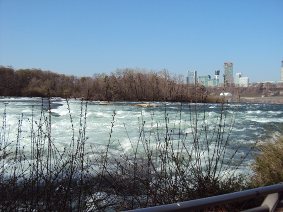
The truly narrow
The
Mighty Niagara River roaring across the Niagara Isthmus between Lake
Erie on the South and Lake Ontario to the North. The river constitutes a
natural boundary between the prophetic "choice land ... free from all
other nations" (Ether 2:12) and a country whose head of state is the
Queen of Source Article: 12. There is more than one eastern sea in the The Book of Mormon does not indicate that every
mention of a "sea" or "seashore" on the east of principal
Book of Mormon lands, relates to the east sea.
The word lake is never used in the Book of Mormon to
describe a body of water. Hebrew scripture calls a lakes or inland body
of water a "sea"; whether fresh or saltwater. A mighty river can
also qualify as a "sea". (e.g. the The most explicit reference to a Nephite city near "the east
sea" is the city of Moroni. The land and
city of The King James Bible (KJV) does not capitalize the
proper noun "east sea". There is no capitalization in Hebrew. The
1830 edition of the Book of Mormon, possibly at the discretion of the
publisher, capitalizes "East Sea" and "West Sea", but does
not capitalize "sea east" and "sea west" because these
expressions are not proper nouns. The latter indicate relative
directions to seas using the adverbs "east" and "west".
(1830 ed. B of M, pp. 287-288, 363, 415 -
compare to current edition. Alma 22:27,
32-33;
50:34,
Helaman 4:7
respectively) Similar expressions calling out relative directions
to seas are found in the Bible. (e.g. "the sea southward",
Joshua 18:14 and "the great sea westward",
Joshua 23:4) The 1830 edition
of the Book of Mormon uses the expression "
The 1828 Printer's
Manuscript of the Book of Mormon reads "from the
east to the west Sea"
(Alma 22:32). The following passages taken together indicate that
the Book of Mormon east sea, near the headwaters of
"the river Sidon" in the "south wilderness",
was possibly above sea level. In other words, the "east sea"
may have simply been a lake in the southeast highlands near the eastern
end of the "narrow strip of wilderness". (Alma 16:6-7;
17:1;
22:27;
31:3 [consider with
43:22;
27:22];
50:8,
11;
56:25 [consider with
51:22-26;
50:13-14];
59:6-7) Conclusion 6,
the A chain of other lakeshores
(seashores) stemmed northward from this east sea along the
Tonawanda Creek corridor. These lakes are now reduced to marshes. The
Clarendon Linden Fault runs more or less parallel to the Tonawanda Creek
corridor. According to the Book of Mormon, the city of
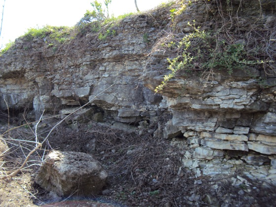
A
portion of the Onondaga Limestone Scarp "... found in seams and in cracks,
and in broken fragments ..." along the Clarendon-Linden Fault. (Helaman 14:21-22) Identifying the Nephite east sea as the
ancient Lake near the Buffalo Creek headwaters, resolves a difficulty
with the placement of the city of After
capturing the city of Connected to the Nephite east sea, a chain
of lakes (seas) existed along the course of the There was a "sea on the east", extending south of
Letchworth Gorge. The northern end of this lake situated about 10 miles
further east of the narrow strip of wilderness
(Zoar Valley, Cattaraugus
River Corridor). (Leverett, Frank, Glacial Formations
and Drainage Features of
the Erie and Ohio Basins, pp.
201, 204, 206, 649)
This "sea, on the east", was the diminished remnant of ancient Anciently, there was
even more water in the Finger Lakes
"many
waters"
region than exists
today. The many rivers and bodies of water that would have had to be crossed
in order to invade the Nephite coast by way of the Finger Lakes
region,
would have arguably posed a greater obstacle than a sea! Coasts can be
traversed by canoe flotillas. Land divided up by rivers, marshes and
lakes force an invading army to either carry their
boats with them or build new ones and or bridges each time they confront
a watery obstacle. This would have given Nephite
hilltops
sentinels in the Finger Lakes region, time to kindle signal fires -
apprising their main armies of an invasion.
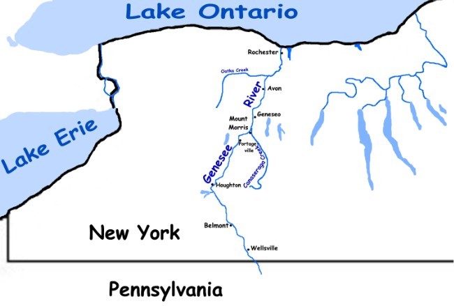
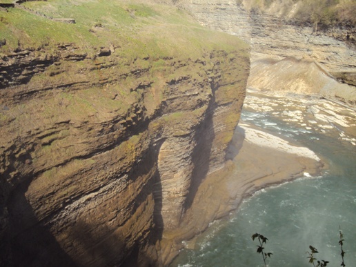
The northward
flowing Genesee River
on the eastern borders of Nephite and Lamanite lands.
A Lamanite army,
intent on invading northern Nephite territories by way of the
land of many waters (Finger Lakes
region), would have to contend with the ancient Genesee and other watery
obstacles.
Nephite sentinels strategically positioned in the
land of many waters could signal the
presence of an invading army by lighting hilltop fires.
Ancient lake
Genesee - a candidate for "the sea on
the east" of the land of Nephi, was south of present-day Portageville.
(Alma 22:27)
The Genesee River
and Gorge, east of Nephite lands.
In the time of Alma
the younger,
the Lamanite armies were "hemmed in" at the southern Bountiful
boarders by Nephite "guards" and "armies"; there being watery boundaries
on the east of Nephite territory and on the west - "the west sea" (Lake Erie). Thus convenient access to more northern lands by way of
the land
Bountiful was
denied the Lamanites.
(Alma 22:33-34)
Nephite "guards" and "armies" stationed outside
Bountiful could
have thwarted invading flotillas launched into "the west sea",
or apprehended war parties attempting to invade the land of many
waters, rivers and fountains.
The Genesee River
at the location of ancient Lake Genesee, east of the land of Nephi.
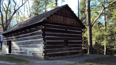
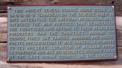
Restored Seneca Council House.
(Alma 19:18)
A long,
fortified line spanning a continental isthmus will not block all
possible routes of attack! The
borders of the true Book of Mormon land Bountiful are described as a
"line"
(Helaman 4:5-7), whereas the entrance to the "narrow pass" is
describes as a "point"
(Alma 52:9)
with water "on the west, and on the east"
(Alma 50:34) - not
on the north and south as seen above!
Source Article: 13.
Scripture consistently describes a general rise in elevation of the land
south of Zarahemla.
(Omni 1:13,
27-28,
Words of Mormon 1:13,
Mosiah 7:1-4,
9,
13;
8:2;
9:3;
28:1-9;
29:3,
Alma 17:8;
26:7-9;
23;
27:5-9;
29:14;
49:10-11;
51:11-13;
53:10-12;
56:3;
57:15-16,
28-30;
62:7,
Helaman 1:17;
4:5;
6:4)
Scripture guides us to the conclusion that the river
There
is no indication in scripture that the river Sidon was a
particularly mighty or impressive river. The Book of Mormon does not
indicate that the river Sidon was used for shipping. Nephite
shipping took place in the "west sea".
(Alma 63:5) Further south, and at
higher elevation, the river at certain seasons was deep and swift enough
to carry away human bodies (ostensibly bloated and made buoyant by
decomposition, Alma 44:22).
Not
surprisingly, the river Sidon could also be crossed on foot near its
elevated headwaters.
(Alma 16:6-7) The American river
The river Kishon of
The southward rolling Mighty Mississippi River is a most unlikely
candidate for the river Sidon.
Identifying the Mississippi River as the Book of
Mormon river Sidon, is analogues to confusing the Nile with Israel's
river Kishon.
Proponents of exaggerated heartland settings desperately seek to match the Mississippi with the river
Sidon. One specious argument alleges that the meaning of the river's
"head" is uncertain in scripture. It is argued that in describing the
"head of the river Sidon", the divine translation does not afford
sufficient information to determine what the term "head" actually means
in this instance. 19th century English dictionaries on the
other hand, plainly relate the
"head"
or
"head water"
of a river to the
river's
"source"
- the place where the river originates. A river's
"head" resides at higher elevation relative to the river's main course
or flow. The location of a river's source at higher elevation is why the
source is called the
"head".
(Oxford English Dictionary, HEAD: 16, 17) The source or
"head"
of the Nile, for
example, is not the same as the confluence of the White Nile and the
Blue Nile at lower elevation.
Heartland setting advocates however, seek to gin an argument out of the
fact that there is another 19th century usage of
"head"
meaning
"conflux". But the context of this usage has to do with a
"body". It is
true that gathering fluids (conflux or confluence) in a body can be
called a
"head"
- but the question needs to be asked whether this usage
was generally extended to the confluence of rivers. Can it be shown that the
confluence of the Missouri and Mississippi rivers was actually called
the
"head"
of either river? Mound Builder authority Roger Kennedy
does not refer to the confluence of the
Missouri and Mississippi Rivers as the head of either
river.
(Roger G. Kennedy, Hidden Cities - The Discovery
and Loss of Ancient North American Civilization,
pg. 19) Where
can we find
a historical source calling the confluence of rivers the
"head"
of one or more river?
Is there any historical source, for instance, calling the confluence
of the White Nile and the Blue Nile, the
"head"
of the Nile?
Heartland setting advocates point to a footnote for
Genesis 2:10
found in LDS scripture, and allege that here is scriptural precedence for
defining any confluence of rivers as a
"head". On the topic of the four
rivers joined in the vicinity of Eden, the footnote reads,
"HEB
divided into four heads (branches)."
Consulting the Hebrew Bible and Lexicon,
however, reveals that the word for
"branches"
does not exist in
this verse. The actual Hebrew word used in
Genesis 2:10, is
"rashim"
(רָאשִׁים), and it literally means
"heads". Why is the root word
"rosh"
which means
"head", "chief" or "first", used in this verse? It's because
the verse is describing the source of each river at higher
elevation - in other words, the high points from which each river
flows. Water, of course, flows from its source at higher
elevation (its
"head") to lower elevation! Therefore the source of a
river delta can also be called the
"head" of the delta. This
"source" is
at higher elevation than the branches of the delta. We would not
properly call this the
"head of the river", but the
"head of the river delta". There is nothing in Hebrew Scripture justifying the
generalization that any confluence of rivers can be termed a river's
"head".
There is really no ambiguity in the meaning of the "head of the river
Sidon" or the general direction of the river's flow.
(Alma 22:27,
29;
43:22;
50:11) The problem lies in trying to make the scriptural river
fit a spurious setting. The "head of the river Sidon" refers to the
source of the river - plain and simple! While scripture does not
explicitly say that the river flows northward, we nevertheless know from
scripture that the river flows northward because its headwaters situate
in southern highlands.
(Alma 16:6-7;
22:27) It's not surprising that there
is no mention of the river in the elevated land of Nephi, south of the
river's "head".
(Omni 1:12-13,
Mosiah 7:1-2,
Alma 50.8-9,
11;
56:25) The
river Sidon does not flow through or past the elevated land of
Nephi, south of its headwaters. It flows northward, passed the land of Zarahemla
(Alma 2:15); and is never mentioned further north; possibly
because, like the Kishon brook of Israel, the river turns out to sea before
reaching more northern lands. Conclusion 7,
river Sidon: Buffalo Creek originates in the southern
highlands of western New York, near the eastern end of the Cattaraugus
River Corridor (the narrow strip of wilderness) not far from the shores
of the east sea and ancient Lake Genesee (the
"sea, on the east" of
the land of Nephi, Alma 22:27). The creek flows northwards before
turning westward to
The river Source Article: 14.
There are natural barriers to the north of Book of Mormon lands in the
form of large bodies of water. (Helaman 3:3-4,
3 Nephi 4:23;
7:12,
Alma 50:29) In the distant north resides a land that is bordered
in all four
cardinal directions by seas. (Helaman 3:8) A careful reading of Helaman
3:8 reveals that the Nephites spread out in the
"land southward", and then
migrated northward where they spread out over the face of the
"land northward". It is important to realize that the frame of reference
directing to the four seas, is in the
"land northward". The names of the
seas are not mentioned in Helaman 3:8,
only their relative directions. This distant northern land is
beyond the borders of the Captain Moroni "named all the land which was south
of the land Desolation, yea, and in fine, all the land, both on the
north and on the south"A chosen land, and the land of liberty." (
Though the
Conclusion 8, the Surrounding Seas of the Land Northward:
Crossing beyond the Niagara River and traveling westward through the 20
mile wide isthmus between Lake Ontario and Lake Erie, one arrives in a
land where Lake Erie (the Nephite west sea) is on the south,
Georgian Bay is to north, Lake Huron is on the west and Lake Ontario is
east. Within and to the north of this region are "large bodies of
water and many rivers" (Helaman 3:4)
A distant land northward surrounded by seas Source Article: 15. There are several plains named in the American
lands of the Book of Mormon. The plains of Heshlon and Agosh
reside in the northern land of the Jaredites. (Ether 13:28;
14:15-26)
The plains of Nephihah (Alma 62:18-19), were in the vicinity of
the Book of Mormon east sea. (Alma 51:26) Plains existed between the fortified city of Hills are mentioned by name in the Book of Mormon"s Conclusion 9,
Plains: Extensive plains reside in western
Plains near the land
"The Book of Mormon
is a record of the forefathers of our western tribes of Indians ... after
having been hid up in the earth for the last fourteen hundred years,
containing the word of God which was delivered unto them. By it we learn
that our western tribes of Indians are descendents from that Joseph who
was sold into 
![]()
.JPG)